 |
 |
 |
 |
 |
Click here for
Additional
Project Details
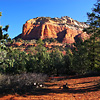
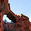
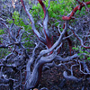
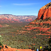
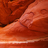
- Location: Devil's Bridge, Sedona, Arizona
- Camera: Canon 5D
- Image Description:This was a fairly easy trail to hike, but well worth it for the views. The bridge itself is a very cool thing to see IMHO.
- Publications:
- Awards:
- Location:About 42 miles south of Flagstaff (12 miles west of Sedona) on paved and graveled roads.
- GPS:GPS: N34° 54' 10.26", W-111° 48' 49.716"
- Access:Drive 27 miles south from Flagstaff to Sedona on US 89A. Continue through Sedona to Dry Creek Road (FR152) at the west end of town. Turn right on Dry Creek Road and drive for two miles to where FR152 forks and take the right fork (leaving the paved road). This road is rough, but can be traveled by passenger vehicles, high-clearance vehicles recommended. It is not recommended during wet weather. About 1.3 miles up this road, turn right to Devil's Bridge Trailhead and parking lot.
- Project Address:For more information contact Red Rock Ranger District, P.O. Box 20429, Sedona AZ 86341, (928) 282-4119
- Project Website:http://www.fs.fed.us/r3/coconino/recreation/red_rock/devils-bridge-tr.shtml
|


